• Skip to primary navigation
  • Skip to main content
  • Skip to footer

Watch “By her own consent”: Mary Ashford and Rape Culture in the Georgian Era

  • Facebook
  • Instagram
  • Twitter

Naomi Clifford

Recovering stories of women in history

  • Books
  • About
    • About the author
    • Press and reviews
    • Agent
    • Contact
  • Blog
    • Browse the blog
    • Mary Ashford
    • Women and the Gallows
    • Maria Glenn
  • News & Events

Maps and Gazetteers

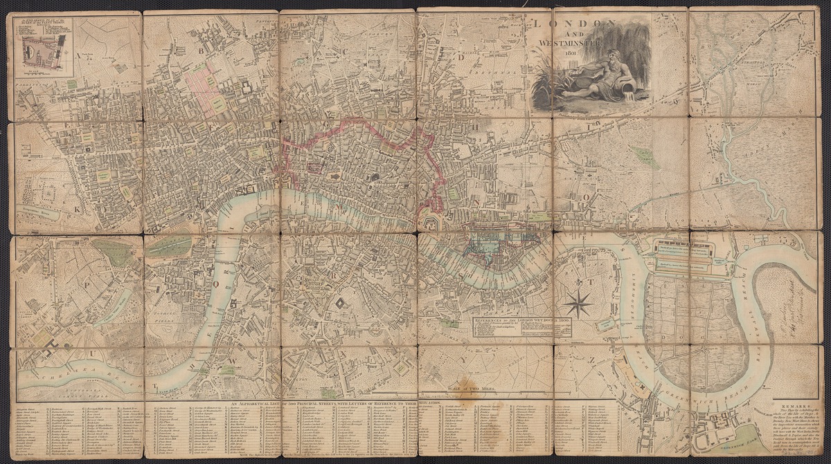
J. Fairburn (1801), London and Westminster. Beineke Library.

This is not meant to be an exhaustive list; rather, it is a place to start when you are looking for maps to help your research. Some of the entries are themselves lists of external links. Copyright is for you to assess.

See also my list of Image databases.
 

ARCHI UK

Includes a set of 52 high resolution English County maps dating from 1724.

ARMSTRONG’S ACTUAL SURVEY OF THE GREAT POST-ROADS

An Actual Survey of the Great Post-Roads Between London and Edinburgh, With the Country Three Miles on Each Side, this edition published in 1783.

BEINEKE RARE BOOK AND MANUSCRIPT LIBRARY (YALE)

One of the world’s largest libraries devoted entirely to rare books and manuscripts.

BRITISH CARTOGRAPHIC SOCIETY

This directory lists the major map collections in the UK. It is freely available subject to the Society’s Terms and Conditions. Use the filter on the right to browse for collections, or the “Search for a Collection” box to find more specific collections.

BRITISH HISTORY ONLINE

Historic maps of London from before 1800 and maps from the 19th-century series of the Ordnance Survey, including the complete 1:10,560 series and selected areas of the 1:2,500 maps. The Ordnance Survey maps can searched by keyword, title or postcode. Several 17th-century maps of London.

BRITISH LIBRARY

A list of British Library map collections that are available online.

NATIONAL LIBRARY OF SCOTLAND

Zoomable, high-resolution colour maps dating from between 1560 and 1964, primarily related to Scotland but also including England and Great Britain, Ireland, Belgium, and Jamaica. There are also maps made for military purposes and Ordnance Survey.

GAZETTEER OF BRITISH PLACE NAMES

An exhaustive Place Name Index to Great Britain, containing over 50,000 entries. It lists the historic county and the main administrative areas in which each place lies. Read the accompanying notes before using.

THE GRUB STREET PROJECT

This digital project, which looks at the topographies of literature and culture in 18th-century London, is run by Allison Muri of the University of Saskatchewan, and helpfully gives access to a selection of maps and views of London from 1558 to 1799.

HISTORIC BUILDINGS

Building historian Jean Manco’s extensive site is included in my Image databases page. The page on maps is a good starting point for your research.

LAYERS OF LONDON

A map-based history website developed by the Institute of Historical Research. Users can access free historic maps of London and contribute stories, memories and histories to create a social history resource about their area. Includes Booth’s Poverty Map.

MAP HISTORY

An extraordinary labour of love, the work of one person who has generously put their non-commercial mixture of comment and tips online, along with thousands of links to free sites.

OLD-MAPS.CO.UK

Over 1 million historical map images, including Ordnance Survey County Series maps from 1843 to approximately 1996.  Maps are free to view online and images can be purchased as file, prints (framed and unframed). A paid-for service (subscriptions are £9.99 per month) gives an enhanced view and discounts.

OLD MAPS ONLINE

A collaborative project to index over 400,000 historical maps in archives and libraries, with many participating institutions.

PATERSON’S ROADS

A great resource for historical fiction and non-fiction writers. There were 18 editions of Paterson’s Roads between 1771 to 1829, a form of gazeteer describing roads (and their landmarks) in England and Wales, as well as direct routes from London to seaports and coastal towns and cross-roads. There is also and index of ‘country seats, places, prospects, antiquities, and remarkable objects, and an appendix.

1778

1796

1808

1811

1826

1832

UNIVERSITY OF MANCHESTER

A list of useful map websites, with a focus on the North.

VISION OF BRITAIN

A vision of Britain from 1801 to now. Including maps, statistical trends and historical descriptions. Of most relevance: Ordnance Survey First Series 1:63360 (170 sheets covering England and Wales, 1805 to 1869);
C. Smith New Map of Great Britain and Ireland 1:633600 (4 sheets covering Great Britain, 1806); R. Wilkinson The British Isles 1:2000000 (1 sheet covering Great Britain, 1812). The site is run by the University of Portsmouth and partners.

Footer

historical writers association logo
pen & sword books logo
  • Books I have reviewed
  • Stories by guest bloggers
  • Image databases
  • Map websites
  • William Cobbett’s State Trials
  • In Our Time index

Search the website

Subscribe to my newsletter

New stories direct to your inbox.

SIGN UP NOW

Copyright © 2021 Naomi Clifford
Privacy policy